
On Thursday Nov 13, 2025 we hosted a webinar with a number of expert speakers discussing city heat and how to address it.

Cities were not designed for the climate they are facing today. Heatwaves are more frequent and more intense, and the familiar “urban heat island” effect is no longer just an academic term – it is a daily reality for residents, businesses, and city services.
Yet most cities still rely on a handful of weather stations, often at airports or on rooftops, to understand conditions on the ground. The result: planners and decision-makers are forced to manage highly local problems with very coarse information.
At Senzemo, together with our partners and customers, we are helping cities move from climate averages to street-level climate intelligence – using dense microclimate sensing and high-resolution modeling to understand and act on heat at the scale where people actually live.
Below are three examples from our recent City Climate Solutions webinar that illustrate what this looks like in practice.
Celje, Slovenia: Transforming a Historic Street with Microclimate Data
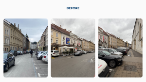
In Celje, a small historic street had effectively become a corridor for cars and parked vehicles, with little green space and almost no shade. Pedestrian counts showed strong foot traffic, but surveys consistently reported one issue: the north side of the street was simply too hot and uncomfortable to use during much of the day.
To move beyond perception, the city installed Senzemo SMC30 microclimate sensors on both sides of the street. Over the summer, measurements revealed that the sunny side was consistently around one degree Celsius warmer than the shaded side. That difference might look small on paper, but for pedestrians, parents with strollers, and elderly citizens, it is very real.
Armed with data, the city:
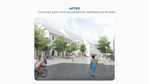
Designed a new shared-space concept with reduced car presence
Introduced trees in large planters and more seating
Planned a long-term monitoring approach: measuring again after construction, and again once trees are established
The redesigned street will not only look better – it will be instrumented to prove how much cooler and more comfortable it becomes over time.
Cary, North Carolina (USA): A Smart Park
In Cary’s new downtown park, technology and landscape design are tightly integrated. Across a 7-acre area, the town deployed:
- Around 300 IoT sensors, connected via a single LoRaWAN gateway
- Dozens of Wi-Fi access points and edge devices
- Multiple Senzemo microclimate sensors to monitor temperature and comfort at key locations

The goal is not technology for its own sake, but operational intelligence. The data supports:
Horticulture decisions: where specific plants and tree species will thrive under real microclimate conditions
Visitor comfort: understanding how different areas heat up during the day and ensuring sufficient shade, water, and rest areas
Smarter maintenance: monitoring trash bin levels, restroom usage, and surface temperatures to target staff interventions where and when they are needed most
Cary is now extending this thinking to nearby sports facilities, including open-walled fields and synthetic turf. Players reported extreme heat on artificial surfaces; Senzemo sensors will provide objective data on temperature differences between natural grass, artificial grass, and other materials.
All data is exposed through dashboards and an open data portal, enabling schools, researchers, and citizens to engage directly with their local climate.
Coburg, Germany: Turning Heat Mapping into a Public Service
Coburg’s historic city center combines narrow streets, dense buildings, and limited airflow – a classic recipe for urban heat islands. Working with the municipality, 50 Senzemo SMC30 sensors were deployed at carefully selected points:
- Busy squares and pedestrian routes
- Parks and green areas near buildings
- Key social and service locations

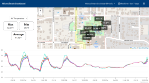
This network feeds an online map showing near real-time temperature patterns across the city. The focus is twofold:
Immediate protection: Residents can see where conditions are most critical and seek cooler areas; vulnerable groups such as children and the elderly can be better protected.
Long-term insight: Over several years, the city will build a robust dataset on how climate change and local interventions (trees, materials, shading) affect actual conditions.
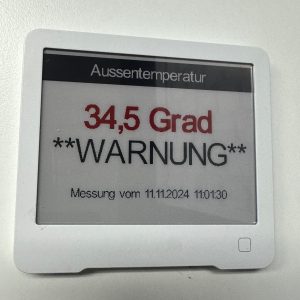
Coburg is now implementing a heat warning system. Residents will be able to register their home address, and the system will track the nearest sensors. When predefined thresholds are exceeded, the resident receives an email or SMS notification. Hospitals, nursing homes, and kindergartens can be equipped with simple, battery-powered local displays showing live temperature and alerts, all connected via LoRaWAN.
This is a concrete example of how microclimate sensing can evolve from a pilot into a public health tool.
From Pilot Projects to City-Wide Climate Intelligence
What connects Celje, Cary, and Coburg is a shared shift:
From intuition (“this area feels hot”)
To evidence (“this location is consistently 2–3°C warmer between 12:00 and 17:00”)
To action (trees, shading, operational changes, warnings)
And back to measurement (quantifying the effect of those actions)
However, ground sensors alone are not enough. They tell the truth where they are installed, but cities also need spatially continuous coverage – the ability to see every 10×10 meter across the urban fabric, not just dozens of sensor locations.
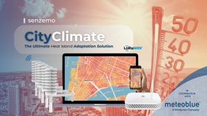
City Climate: Senzemo & Meteoblue
Click here for more info about CityClimate in PDF
To address this, Senzemo has partnered with Meteoblue to create City Climate – a combined offering that merges:
Senzemo SMC30 sensors
– Battery-powered LoRaWAN microclimate devices (temperature, humidity, pressure)
– Easy to deploy in dense urban environments
Meteoblue’s high-resolution climate modeling
– Uses satellite imagery and advanced numerical models
– Delivers real-time and forecast heat maps at ~10 m resolution
– Provides urban heat island indicators, history, and scenarios
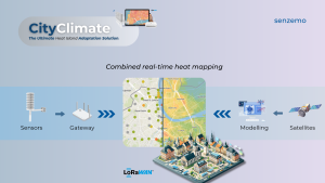
Local sensor data continuously calibrates and improves the model, significantly reducing temperature errors and providing a far more accurate picture of conditions at street level.
This integrated approach enables cities to:
- Evaluate the impact of planned interventions (e.g., new trees, materials, or street layouts) before implementation
- Monitor the effect of completed projects over time
- Prioritize investments in the most critical hotspots
- Operate smarter during heatwaves (targeted watering, shading, communication, and warnings)
For medium and large cities, 20–50 strategically placed sensors, combined with robust modeling, can already provide very high value – without requiring thousands of devices.
The Technology Is Ready. The Question Is: Are We Ready to Use It?
LoRaWAN connectivity, long-life battery sensors, and mature urban climate models are available today. The remaining challenge is no longer technical; it is organizational.
Cities that are willing to let data shape planning, budgeting, and operational decisions will be better prepared for hotter summers, more frequent heatwaves, and increasing pressure on infrastructure and health systems.
At Senzemo, we believe that every city can start listening to its own heat – beginning with a few carefully chosen locations and growing into a comprehensive climate intelligence layer.
SEE WHOLE WEBINAR:

Want to explore City Climate for your city or project?
We are happy to discuss:
- Pilot deployments for streets, parks, or districts
- Integration with existing LoRaWAN networks and platforms
- Joint projects combining Senzemo sensing and Meteoblue modeling
Feel free to contact us to learn how Senzemo can support your city’s climate resilience strategy. Email us at blaz.kastelic@senzemo.com.